


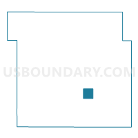
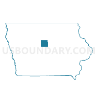
JEWELL JUNCTION Voting District, Hamilton County, Iowa
About
Outline

Summary
| Unique Area Identifier | 582231 |
| Name | JEWELL JUNCTION Voting District |
| County | Hamilton County |
| State | Iowa |
| Area (square miles) | 4.00 |
| Land Area (square miles) | 3.87 |
| Water Area (square miles) | 0.12 |
| % of Land Area | 96.93 |
| % of Water Area | 3.07 |
| Latitude of the Internal Point | 42.31015320 |
| Longtitude of the Internal Point | -93.63875070 |
Maps

Graphs
Select a template below for downloading or customizing gragh for JEWELL JUNCTION Voting District, Hamilton County, Iowa


Neighbors
Neighoring Voting District (by Name) Neighboring Voting District on the Map
- ELLSWORTH TWP Voting District, Hamilton County, IA
- LYON TWP W/O ELLSWORTH & JEWELL JUNCTION Voting District, Hamilton County, IA